

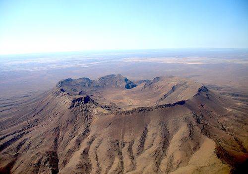
Brukkaros
Brukkaros VolcanoRising starkly from the desert plain is an extinct volcano, visible from from the B1 between Mariental and Keetmanshoop. Brukkaros Mountain dominates the landscape and its distinctly circular, rimmed shape, towers some 650m above the surrounding environment. The crater has a diametre of about 3km (2miles) and its floor lies some 350m (1,148ft) below the rim. The name Brukkaros combines the Afrikaans name broek (trousers) and karos (leather apron) in deference to the Nama name, Geitsigubeb, a traditional article of clothing worn by Nama women.
Brukkaros was formed some 80 million years ago when a magma pipe, molten rock with a mixture of mineral or organic matter in a thin, pastry state, came in contact with groundwater about 1,000m below the earth's surface. The water heated to dynamic proportions, vapourized and expanded, causing the surface to swell into a bulge, 10km across and 500m high. More magma managed to intrude into the empty space, which in turn heated more water and caused further swelling. Something had to give and the resulting explosion caused the surface material and all of the water to collapse into the magma pipe, setting off further explosions.
Subsequently, material was ejected from deep in the earth and deposited around the gaping crater, forming a rim. In time, hot springs appeared in the crater, creating a lake and deposited quartz and other minerals. Over the following millions of years, erosion removed all the surrounding material, leaving the 650m erosion-resistant 'plug' on view today.
Visitors to Brukkaros can follow a 3.5km track to the crater's southern entrance from the car park, accessible by 4x4. There are some amazing crystal formations embedded in the rock en-route and as you approach the crater entrance, the trail traverses the wall of the crater's outflow canyon, high above an intermittent water-fall! At the entrance, explorers have a choice. You can either head to the kokerbooms (quiver trees) and crystal fields on the crater floor, or follow the route which turns sharply left and climbs to an abandoned research station on the rim. The walk takes 2½ hrs each way, so take plenty of water!
Camping under clear Namibian night skies is a magical experience, and there a number of basic camp sites in and around the car park. But as there are no restrictions where you can camp, and pitching a tent in or around the crater rim is much more exciting!
.png?width=82&height=85&name=Navigate%20Namibia-03%20(1).png "Navigate Namibia")